Intro to Meterology Assignment Three
Analyzing a Severe Thunderstorm
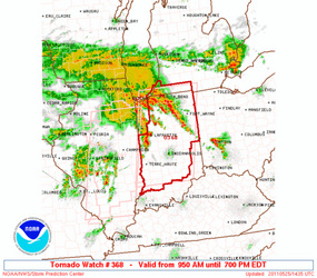
An urgent notification for a tornado watch is issued for this area from the Oklahoma Storm Prediction Center. The watch includes portions of Indiana, Southwest Lower Michigan and Lake Michigan. It is for the entire day of May 25,
2011, morning to evening. The statement warns of possible hail, up to two inches in diameter, wind gusts up to
seventy miles per hour and lightening.
Tornado watches are issued when conditions are favorable for their development. Tornadoes, also called twisters or cyclones, result from a rotating column of air. They come down from cumulonimbus clouds. They can form from any storm that produces severe weather such as cold fronts and tropical cyclones. A precondition tied to tornado formation in severe thunderstorms is the development of a ‘mesocyclone’, a vortex of air that rises and rotates around a vertical axis. The rotating column of air narrows and stretches downward and may become a fast spinning funnel cloud that will come from a slowly rotating wall cloud. If the funnel cloud makes contact with the surface, it is then classified as a tornado.
Severe thunderstorms, and therefore tornadoes, are most often spawned along the cold front or squall line of a middle-latitude cyclone or in association with super cell thunderstorms. Hail can form in tornado inducing storms because like tornados, hail forms most tall cumulonimbus storms that reach the cold upper atmosphere.
Hail, little clumps of ice. are kept up by strong winds and blown through thunderclouds until they are heavy
enough to fall to the ground.
Wind gusts are very likely in a storm that had a tornado watch because high wind speeds result from downdrafts from the thunderstorm cells reach the surface and spread out to produce an advancing wedge of cold air, called a gust front, which may form a roll cloud as warm air is lifted along its leading edge.
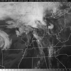
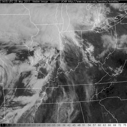
The visible satellite image shows the actual cloud mass while the infrared shows the heat generated from the storm.
This is interesting because when I first pull up both images I thought that they looked very similar but the visible image is much more detailed. The infrared was taken at UTC 14:33, which is 7:33 here in Utah.
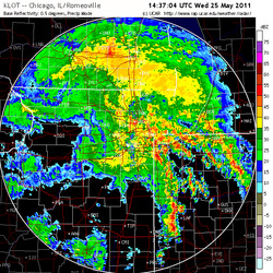
The colorful Doppler image is the most colorful showing
temperatures and precipitation.
This one was in precipitation mode and shows that quite a bit of rain
came out of this storm.
Reflection:
Severe weather forecasts are something to take seriously. As random and rare as a tornado is to those of us living in the Salt Lake area of Utah they are still not unheard of. In other parts of the country they are a part of life and severe weather forecasts are a very necessary and relied on source of information. Knowing what to expect of a predicted storm, such as the possibility of hail and wind that can cause damage to personal property and other social
infrastructures such as power lines, helps us all take precautions. Understanding how weather predictions are made gives me the ability to take action individually to prepare for severe weather.