Intro to Meterology Assignment Two
Weather Forecasting
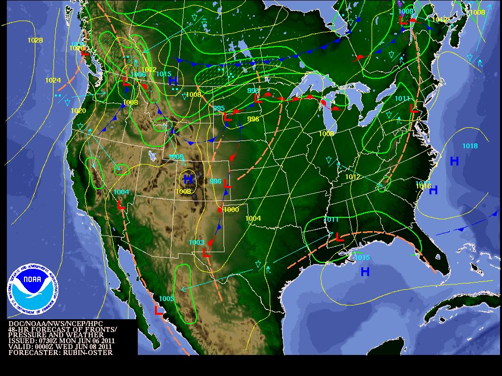
The Date and time for the 48-hour forecast was retrieved on June 6, 2011 at 11:00am MST or 17:00 Zulu. This forecast
was for the KMOS airport in Missoula, MT and it predicted heavy rain and wind for the area.
was for the KMOS airport in Missoula, MT and it predicted heavy rain and wind for the area.
The forecast was really close to being accurate. I pulled the forecast for Missoula, MT at 11am on June 8, 2011. The forecast map stated it was generated at 7:30 Zulu time. When I looked at the METAR 48 hours later there was ‘no significant weather observed at this time’.
Aviation Digital Data Service (ADDS)
Output produced by METARs form (1746 UTC 08 June 2011) found at http://aviationweather.gov/adds/metars/index.php
METAR text: KMSO 081653Z 34007KT 10SM FEW030 OVC055 08/06 A3000 RMK AO2 RAE18 SLP160 P0001 T00830056
Conditions at: KMSO (MISSOULA , MT, US) observed 1653 UTC 08 June 2011
Temperature: 8.3°C (47°F)
Dewpoint: 5.6°C (42°F) [RH = 83%]
Pressure (altimeter): 30.00 inches Hg (1016.0 mb) [Sea-level pressure: 1016.0 mb]
Winds: from the NNW (340 degrees) at 8 MPH (7 knots; 3.6 m/s)
Visibility: 10 or more miles (16+ km)
Ceiling: 5500 feet AGL
Clouds: few clouds at 3000 feet AGL overcast cloud deck at 5500 feet AGL
Weather: no significant weather observed at this time
When looking back a few hours earlier at 1253 the report advised of heavy rain and mist in this area:
Aviation Digital Data Service (ADDS)
Output produced by METARs form (1746 UTC 08 June 2011) found at http://aviationweather.gov/adds/metars/index.php
METAR text: KMSO 081253Z 30011KT 2 1/2SM +RA BR FEW018 OVC035 09/08 A2993 RMK AO2 RAB1158 SLP131 P0005 T00890078
Conditions at: KMSO (MISSOULA , MT, US) observed 1253 UTC 08 June 2011
Temperature: 8.9°C (48°F)
Dewpoint: 7.8°C (46°F) [RH = 93%]
Pressure (altimeter): 29.93 inches Hg (1013.6 mb) [Sea-level pressure: 1013.1 mb]
Winds: from the WNW (300 degrees) at 13 MPH (11 knots; 5.7 m/s)
Visibility: 2.50 miles (4.02 km)
Ceiling: 3500 feet AGL
Clouds: few clouds at 1800 feet AGL overcast cloud deck at 3500 feet AGL
Weather: +RA BR (heavy rain, mist)
Aviation Digital Data Service (ADDS)
Output produced by METARs form (1746 UTC 08 June 2011) found at http://aviationweather.gov/adds/metars/index.php
METAR text: KMSO 081653Z 34007KT 10SM FEW030 OVC055 08/06 A3000 RMK AO2 RAE18 SLP160 P0001 T00830056
Conditions at: KMSO (MISSOULA , MT, US) observed 1653 UTC 08 June 2011
Temperature: 8.3°C (47°F)
Dewpoint: 5.6°C (42°F) [RH = 83%]
Pressure (altimeter): 30.00 inches Hg (1016.0 mb) [Sea-level pressure: 1016.0 mb]
Winds: from the NNW (340 degrees) at 8 MPH (7 knots; 3.6 m/s)
Visibility: 10 or more miles (16+ km)
Ceiling: 5500 feet AGL
Clouds: few clouds at 3000 feet AGL overcast cloud deck at 5500 feet AGL
Weather: no significant weather observed at this time
When looking back a few hours earlier at 1253 the report advised of heavy rain and mist in this area:
Aviation Digital Data Service (ADDS)
Output produced by METARs form (1746 UTC 08 June 2011) found at http://aviationweather.gov/adds/metars/index.php
METAR text: KMSO 081253Z 30011KT 2 1/2SM +RA BR FEW018 OVC035 09/08 A2993 RMK AO2 RAB1158 SLP131 P0005 T00890078
Conditions at: KMSO (MISSOULA , MT, US) observed 1253 UTC 08 June 2011
Temperature: 8.9°C (48°F)
Dewpoint: 7.8°C (46°F) [RH = 93%]
Pressure (altimeter): 29.93 inches Hg (1013.6 mb) [Sea-level pressure: 1013.1 mb]
Winds: from the WNW (300 degrees) at 13 MPH (11 knots; 5.7 m/s)
Visibility: 2.50 miles (4.02 km)
Ceiling: 3500 feet AGL
Clouds: few clouds at 1800 feet AGL overcast cloud deck at 3500 feet AGL
Weather: +RA BR (heavy rain, mist)
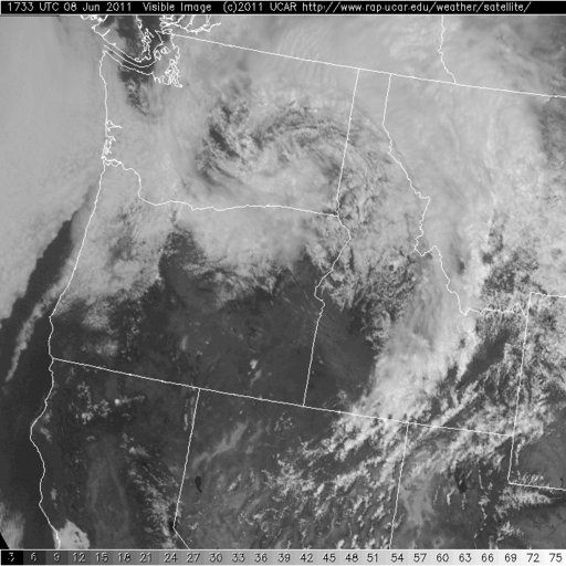
Infrared and Visible Images
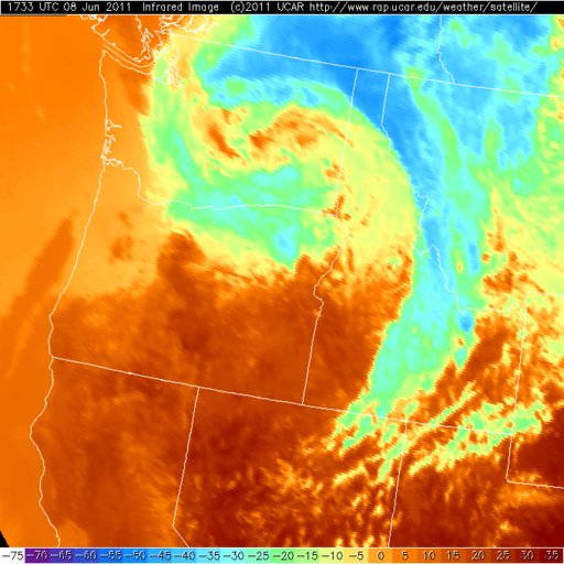
Visible and infrared images show a clear cyclone with low and high pressures meeting to create a disturbance. The infrared image has a clear blue cold front in the north meeting the southerly red warm
front and a cyclone spinning in the center. The Visible image below shows the cloud cover.
front and a cyclone spinning in the center. The Visible image below shows the cloud cover.
Doppler Image
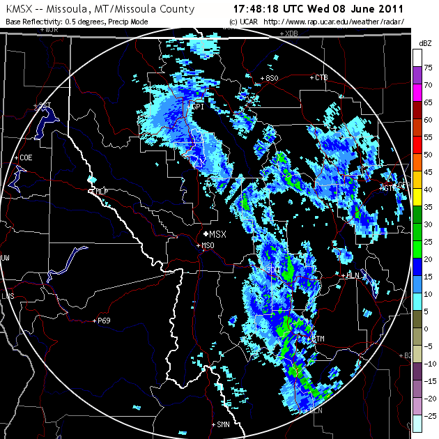
The Doppler image, a closer view of Missoula, MT, shows precipitation along the eastern edge.
Reflection
Understanding how weather affects all of us is an easy task. Sunny and warm means most of us will be outside. The opposite holds true. Understanding the science and how predictions are made for weather is not as easy. It is incredibly important for me personally to better be able to see incoming weather to make decisions
about where and when I can paraglide. Having a solid understanding of maps and the meanings in those maps helps me make plans for a coming weekend or excursion to a new area. I have understood the benefits of a High pressure as it heralds good conditions. Cold fronts generally mean storms.
I recently went on a trip to San Bernardino’s to fly the Marshall Mountains and planned this trip ahead of time.
The other pilots going had studied the weather maps available to make a good guess for the best weekend to go. This is a large part of my motivation to take this class.
